
Comment
I have been examining the eleven maps that accompany ERO posting 019-6216 that show the areas being removed from the Greenbelt and those being added in relation to their natural functions and agricultural use based on their geophysical locations as per satellite imagery, and compared their functions to the objectives of the Greenbelt Act, which are as follows:
The objectives of the Greenbelt Plan are,
(a) to establish a network of countryside and open space areas which supports the Oak Ridges Moraine and the Niagara Escarpment;
(b) to sustain the countryside, rural and small towns and contribute to the economic viability of farming communities;
(c) to preserve agricultural land as a continuing commercial source of food and employment;
(d) to recognize the critical importance of the agriculture sector to the regional economy;
(e) to provide protection to the land base needed to maintain, restore and improve the ecological and hydrological functions of the Greenbelt Area;
(f) to promote connections between lakes and the Oak Ridges Moraine and Niagara Escarpment;
(g) to provide open space and recreational, tourism and cultural heritage opportunities to support the social needs of a rapidly expanding and increasingly urbanized population;
(h) to promote linkages between ecosystems and provincial parks or public lands;
(i) to control urbanization of the lands to which the Greenbelt Plan applies;
(j) to ensure that the development of transportation and infrastructure proceeds in an environmentally sensitive manner;
(k) to promote sustainable resource use;
The objectives above show that the orignal drafters of the Greenbelt Act appear to have had a good handle on the importance of the rural environment, including both agricultural and natural lands. The greenbelt is here to assure that the area surrounding the GTHA can provide many of the natural and agricultural functions that are necessary for the sustainabilty of those living in the area and around it, as well as in the GTHA itself. Any proposal for the removal of lands from the Greenbelt must be thoroughly examined for its long term effects on the important aspects of sustainability. We know that we have made serious mistakes in the past by allowing poorly controlled sprawl into agricultural lands, forests, wetlands, low lying areas, and groundwater recharge areas. With climate change already occurring, which is going to seriously magnify any mistakes we now make in land use planning, it is vital that we make no more such mistakes. The following are summaries of my impressions of some of the parcels proposed to be excluded.
Map 1- (West of Newmarket)
This proposed removal of lands between Newmarket and the Holland Marsh and Bradford is a very serious intrusion into the Greenbelt, which would not only remove a large area of high quality agricultural land from production, effectively forever, but would put tremendous pressure on adjacent properties for their removal if it were to go through.
Map 2 – (Maple)
This small parcel north of Testton Road and between Pine Valley Drive and the stream (flows to the Humber River) to the East provides a land buffer to the stream, which allows for infiltration of rainfall and contributes to reducing peak flow volumes, as well as adding to. It is largely agricultural, and would also be habitat for some wildlife.
Map 3 (Richmond Hill)
These two areas are mostly agricultural and are on the upper reaches of the Rouge River. They therefore provide for groundater recharge and infiltration. The largest portion is too close to the 404 to be suitable for responsible residential development without significant noise amlioration methods.
Map 4 (North Markham)
It appears that these three small parcels are being proposed for removal to align the Greenbelt with existing farming practices and boundaries. This would only need to be done for the purposes of future development of the surrounding properties. Two of the three are almost impossible to locate precisely from the maps given in the posting, but are immediately adjacent to a small tributary of the Rouge River and in the case of future development would help to protect it from encroachment. These would not be good areas for building houses, but all three could serve as useful greenspace and parkland areas if development did occur on adjacent lands.
Map 5 (Markham – Major Mackenzie)
Again, given the poor quality of the maps in the posting, it is extremely difficult to determine reasonably precisely exactly where these four pieces are. Similar to the above, these three of them are immediately adjacent to the upper Rouge and would serve the same functions as the above. The other piece is either in or immeditely adjacent to a wooded area at the upper reaches of the Rouge. The map shows it as an irregular shaped hole in the middle of a fairly narrow part of the Greenbelt , and it doesn’t appear to make any sense at all to remove it.
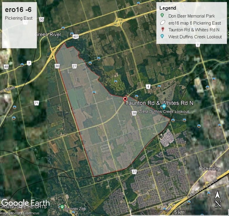
Map 6 (East Pickering)
This is by far the largest piece of land proposed for removal. It is thousands of hectares of farmland, wooded areas, small streams and valleys, and the natural lands adjacent to them. It is immediately west of West Duffins Creek. This area is an extremely important piece of the Greenbelt, with its large area of high quality agricultural land and its natural areas that supply important functions for maintaining sustainability. Removal of this piece would be a slap in the face to the all the purposes of the Greenbelt. Its removal would be an admission of failure by the government to properly address urban planning in its full context of urban/rural/natural relationships and dependencies. Its removal would result in developers banging at the door to remove further Greenbelt lands from its southern extents for the next decade.
Map 7 (Ajax – Whitby)
This property sits in the main visible portion of the Greenbelt along the 401 between Ajax and Whitby. Its removal from the greenbelt would effectively result in the visual loss of the greenbelt on the the north side of the 401, and would effectively end the continuity of the Greenbelt from the Oak Ridges Morraine to Lake Ontario. It is high quality agricultural land that similar to that south of the 401
After looking at the 11 maps that show the lands proposed for removal, I have concluded that these lands cannot be removed on the bases of not fulfilling the objectives of the Greenbelt Act. The web posting provides no individual parcel rationale for removal from the Greenbelt. Many experts and knowledgeable people have shown that there are thousands of acres available for housing development within the GTHA that are not within the greenbelt, and that the government should be looking at these lands before attacking the Greenbelt. The government should be providing a long term plan as to how, over the next few decades, it is going to address legitimate housing issues while fully addressing sustainabilty, instead of jumping to begin the dismantlng of important planning tools, such as the Greenbelt, that do address sustainability. As there is no individual parcel rationale, and as there is no apparent proper long term plan, and, as it has now become apparent that some developers who have donated money to the governing party have recently bought properties within the Greenbelt, these proposals should not move forward until there has been a thorough examination of the communications between the government and the developers and of the role that the development industry plays in the provincial government’s planning and in it’s development of legislation and regulations. .
Supporting documents
Submitted December 4, 2022 8:32 PM
Comment on
Proposed Amendments to the Greenbelt Plan
ERO number
019-6216
Comment ID
79446
Commenting on behalf of
Comment status