
This consultation was open from:
March 23, 2020
to June 8, 2020
Decision summary
We have released a revised study area related to the Northwest GTA Transmission Corridor Identification Study. The study is ongoing, and we will continue to consider the comments received as we move forward with subsequent study milestones.
Decision details
The study team, comprised of the Ministry of Energy, Northern Development and Mines (ENDM) and the Independent Electricity System Operator (IESO), consulted on the “Proposal to identify and protect a corridor of land for future electricity infrastructure in the Greater Toronto Area” for 77 days from March 23, 2020 to June 8, 2020 to gather early feedback on a proposed narrowed area of interest as well as the guiding principles we will consider as we conduct the study going forward. We appreciate all of the feedback received. Comments contributed to the revised 2020 narrowed area of interest.
The changes to the narrowed area of interest are summarized as follows:
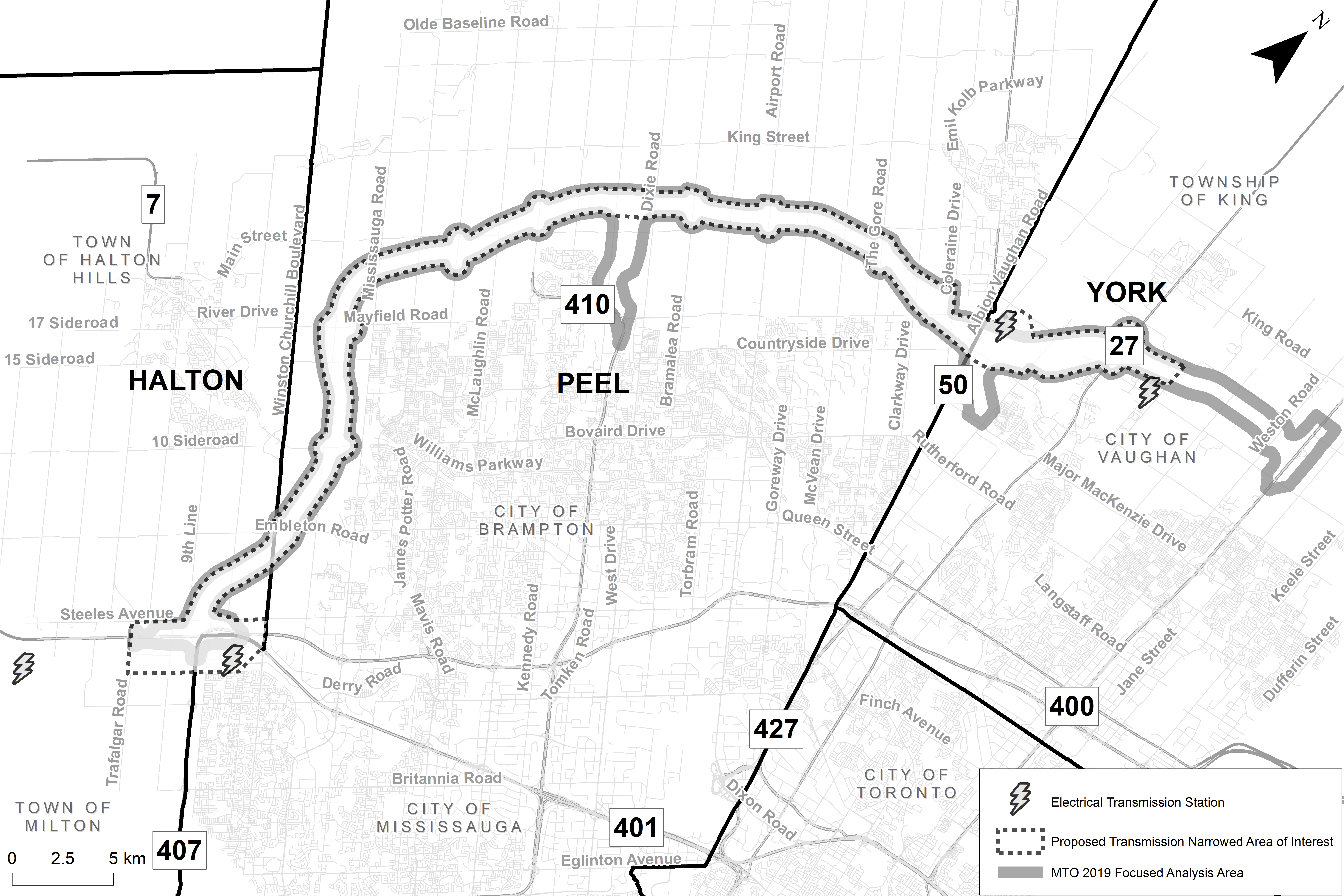
- A number of changes were made to align the narrowed area of interest with MTO’s 2020 Focused Analysis Area for the GTA West Transportation corridor, released on August 7, 2020. The study team heard consistently from stakeholders about the need to closely coordinate the transmission study with the transportation study in order to reduce the impacts on property owners. The study areas continue to diverge in two locations to enable integration of a future corridor with existing electrical infrastructure: the connection to the 230 kV circuits between Milton TS and Meadowvale TS south of the 407 corridor and the connection to Kleinberg TS in southeastern Caledon
- The narrowed area of interest was reduced in the area surrounding the 401/407 interchange area in response to concerns from local municipalities and businesses about the impact of the corridor on existing and planned developments, including key employment lands. The revised narrowed area of interest strikes a balance by being responsive to stakeholder feedback while still preserving a reasonable range of alternatives for transmission siting to investigate further as the study progresses.
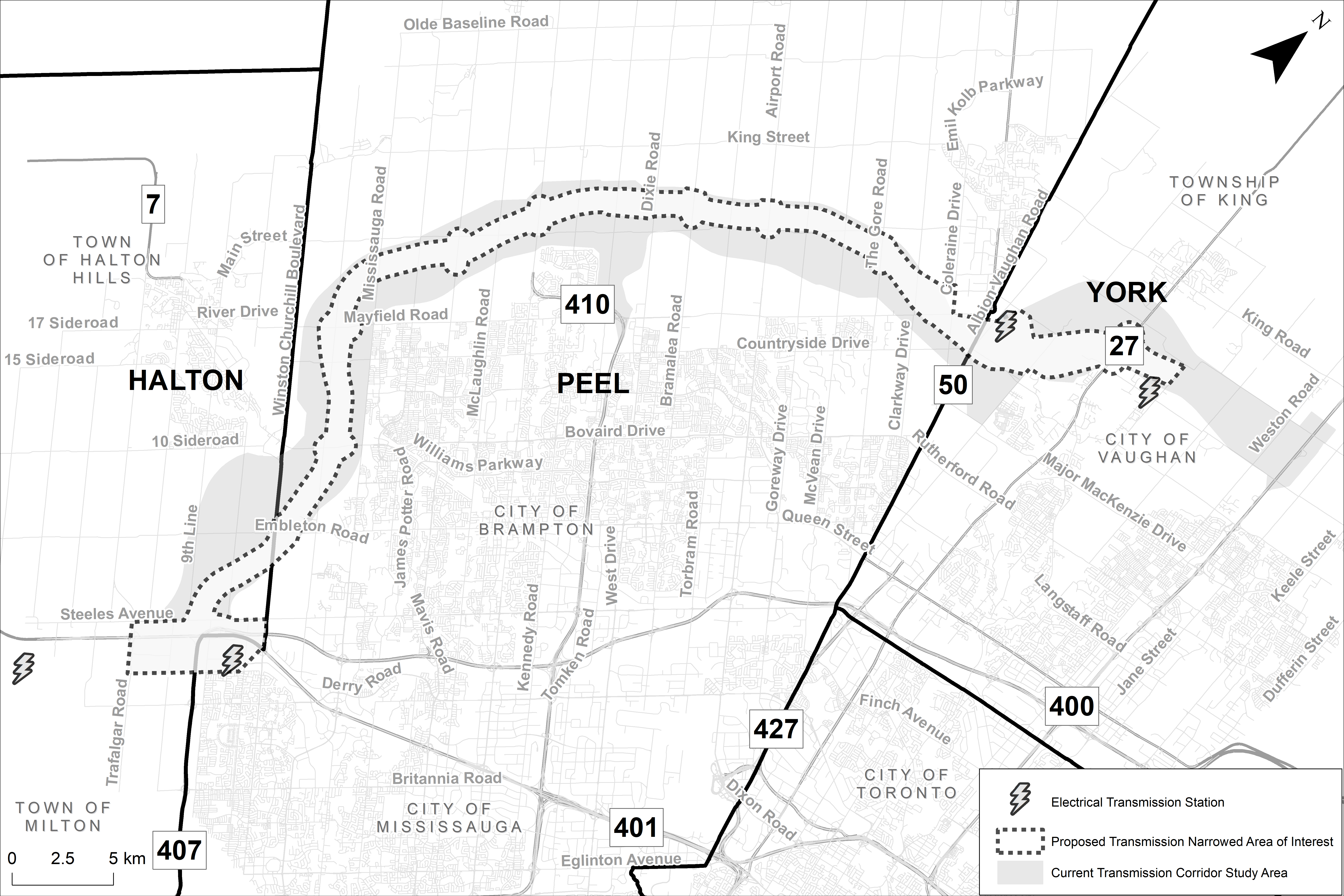
A map (“2020 Narrowed Area of Interest”) comparing the 2020 narrowed area of interest and the 2019 narrowed area of interest are included in the supporting material below, along with a map (“2020 Narrowed Area of Interest compared to MTO’s 2020 Focused Analysis Area”) comparing the 2020 narrowed area of interest with MTO’s 2020 Focused Analysis Area for the GTA West Transportation Corridor Environmental Assessment. The data layers are also available for download on Ontario’s Open Data Catalogue.
The study team will continue to consider the advice received on the guiding principles as well as other feedback as move forward with subsequent study milestones. We also anticipate there will be additional opportunities for engagement in the future.
Effects of consultation
The study team reviewed and considered the comments received on the “Proposal to identify and protect a corridor of land for future electricity infrastructure in the Greater Toronto Area.” We received a total of 45 comments:
Most of the comments received fell into five key themes that are discussed below.
Support for colocation of linear infrastructure
Many commenters expressed support for new electricity infrastructure to support growth and for co-location of future transmission infrastructure with the proposed GTA West Transportation Corridor in order to reduce overall impacts to natural heritage, farmland, and existing and planned communities and employment lands.
Impacts of the study on property owners within the study area, as well as impacts on municipal planning, including plans to develop residential, recreational and employment lands
Many individuals and businesses that own land within the study area expressed concerns about the impacts of the study on their ability to sell or develop their properties. Local municipalities commented about the impact of the corridor on municipal plans, including for key residential, employment and recreation lands. Some commenters requested the study area be realigned to avoid impacts to existing or planned communities, businesses or other developments and many shared comments they had also provided to GTA related to the GTA West Corridor EA. Many of these commenters expressed a desire for the study to be completed quickly, and for timing and route alignment to be coordinated with the Ministry of Transportation’s GTA West Corridor Environmental Assessment.
In response to the feedback received, the narrowed area of interest was reduced in the area surrounding the 401/407 interchange area. The revisions in this area are intended to strike a balance between concerns about impacts to employment lands while still preserving a reasonable range of alternatives to investigate as the study progresses. A number of changes were also made to the narrowed area of interest to align it with changes made by the MTO to their recently released 2020 Focused Analysis Area for the GTA West Transportation corridor.
With regard to completing the study quickly, it is the intention to complete phases of the GTA West Transmission Corridor study as expeditiously as possible. Given the importance of potentially co-locating the transmission corridor with the proposed GTA West Transportation Corridor, the study team intends to align the timing of our study with milestones related to the Ministry of Transportation’s Environmental Assessment. This will include moving forward with further detailed analysis of routing options and future study area refinements.
Combability of transmission infrastructure with other types of infrastructure
The study team also received comments and concerns about the interaction of future transmission infrastructure with other types of infrastructure. This included comments about the impact of a corridor on existing and planned transit and transportation networks, municipal water and wastewater infrastructure, high speed fibre for internet connection, concerns about the corridor’s impact on connectivity within communities, concerns about compatibility with existing hydrocarbon infrastructure and input from a local airport about the potential impact future transmission configurations could have on the airport’s ability to operate safely. A number of comments were received suggesting that we consider the potential for recreation infrastructure, including sports fields, parks, and active transportation networks, such as walking and cycling trails.
The study team will be moving forward with further detailed analysis of the study area to inform routing options. This will include evaluating the range of transmission design options that could allow flexibility to mitigate impacts to other infrastructure. Any future electricity transmission development in the area would be subject to applicable environmental and regulatory approvals and would be expected to comply with relevant national and international standards for the design of its transmission system and equipment, such as those established by the Canadian Standards Association (CSA), the IEEE and the International Electrotechnical Commission (IEC), as well as federal aviation regulations and related guidance. These standards will be an important consideration in determining an appropriate corridor to protect for the future. The study team will also consider further how a future corridor can support community connectivity, including through active transportation networks and other infrastructure, and how the study can be carried out, and a final corridor designed, in a way that does not preclude municipal infrastructure expansions.
Impacts of transmission infrastructure on natural heritage features, agricultural lands and cultural heritage
The study team heard about the importance of protecting the natural heritage system, agricultural lands and cultural heritage and the need to avoid or mitigate impacts of a future transmission corridor and associated infrastructure on these features within the study area. We also heard about the importance of considering potential positive impacts, for example, through naturalization of a future corridor, or urban agriculture.
Identifying a transmission corridor adjacent to the planned GTA West transportation corridor now is intended to help mitigate impacts on surrounding areas. As discussed above, the study team will be moving forward with detailed analysis of the study area to inform routing options. We appreciate the information and advice received through this consultation and anticipate working closely with stewardship organizations and other interested stakeholders to inform this analysis in the coming year.
Health and safety of electricity transmission infrastructure
The study team heard concerns about the health and safety of transmission infrastructure, in particular where it could be sited near existing and planned residential areas, houses of worship and schools.
Any future electricity transmission development in the area would be subject to applicable and environmental and regulatory approvals and would be expected to comply with relevant national and international standards for the design of its transmission system and equipment, such as those established by the Canadian Standards Association (CSA), the IEEE and the International Electrotechnical Commission (IEC). These standards will be an important consideration in determining an appropriate corridor to protect for the future.
Consideration of climate change mitigation and adaptation
The study team also heard about importance of considering climate change mitigation, including ensuring the project supports efforts underway by local communities to build sustainable communities and reduce greenhouse gas emissions, including through electrification, conservation and energy efficiency and alternative energy systems. We also heard about the importance of climate change adaptation in the project’s eventual design.
It is important to note that a recommendation on the specific infrastructure investment required for the region has not yet been made. The IESO will continue to monitor growth and evaluate the region’s needs through ongoing regional electricity planning processes. Through these planning processes, the IESO works closely with municipal partners to assess the needs of each region and assesses a range of alternatives to meet those needs, including locally-sited generation resources and energy efficiency. However, given the long-term nature of the region’s electricity needs, it is important to keep a viable transmission infrastructure option open by ensuring land remains available in the future.
Supporting materials
View materials in person
Some supporting materials may not be available online. If this is the case, you can request to view the materials in person.
Get in touch with the office listed below to find out if materials are available.
77 Grenville St, 6th Flr.
Toronto,
ON
M7A 2C1
Canada
Connect with us
Contact
Cisca McInnis
77 Grenville Street, 6th Floor
Toronto,
ON
M7A 2C1
Canada
Original proposal
Proposal details
Halton, Peel and York are among the fastest growing regions in Ontario. As these regions continue to develop, new transmission infrastructure is anticipated to be required to meet the growing electricity demand over the long-term future.
We’ve identified a long-term need for electricity transmission infrastructure, but the technical scope of the transmission infrastructure required, and the timing of its need, may not be certain for many years.
Given the fast growth occurring in these regions, and the sensitive environmental features in the area, it is important to keep a viable transmission infrastructure option open by identifying a viable corridor today.
In June 2019, the Ministry of Energy, Northern Development and Mines (ENDM) and the Province’s electricity system planner, the Independent Electricity System Operator (IESO) initiated the Northwest GTA Transmission Corridor Identification Study (hereafter “the study”) to identify an appropriate corridor of land for use by future linear transmission infrastructure, if and when the need arises.
Early identification and protection of infrastructure corridors has many benefits for growing communities:
- It supports well-planned communities by ensuring electricity transmission infrastructure can be built to support growth.
- It minimizes impacts to the environment by preserving environmentally viable routes for infrastructure. In the absence of a preserved corridor, development may push electrical infrastructure into ecologically sensitive areas that could otherwise have been avoided.
- It preserves economically-viable routes. In the absence of a preserved corridor transmission would cost significantly more to build because of the need to take indirect routes or to be undergrounded through built up areas. A reserved corridor could lower infrastructure development costs, leading to savings for local electricity ratepayers.
- It provides certainty to municipal planners, landowners and developers as they plan for growth.
We are seeking feedback on a proposed study area, as well as input on the guiding principles we will consider in conducting the study.
While the study is underway, the study area is subject to protection under policies in A Place to Grow: Growth plan for the Greater Golden Horseshoe and the Provincial Policy Statement, 2020 (in effect on May 1, 2020).
The outcome of the study will be a recommendation on land to be preserved for future transmission infrastructure and protected from development for other purposes.
Any future electricity transmission development in the area would be subject to Environmental Assessment Act requirements and other applicable regulatory approvals, including through the Ontario Energy Board.
Electricity infrastructure needs
The IESO, Ontario’s electricity planner, has identified a long-term need for new transmission capacity to serve growth in the north western GTA.
Transformer stations serving northern Brampton, southern Caledon, and Halton Hills face unique geographic challenges in supplying new customer growth which is increasingly far removed from existing transmission supply circuits. This means that once existing capacity has been fully utilized, there are few feasible options for serving new customer demand. Due to the distance between the existing transmission system and areas of anticipated growth, alternatives to new transmission infrastructure are not considered viable.
The timing of the need for transmission infrastructure and the exact nature of the infrastructure required will depend on the timing and location of development in Halton, Peel and York regions.
The electricity needs of these regions will continue to be studied and refined over the coming years, with updated electricity plans anticipated at least every 5 years.
Given the long-term nature of the needs, the fast growth occurring in the Halton, Peel and York regions, and the sensitive environmental features in the area, it is important to keep a viable transmission infrastructure option by identifying a viable corridor today.
The study area
Provincial policy supports the co-location of linear infrastructure which has the potential to mitigate the impact on surrounding agricultural land and environmentally sensitive areas.
Planning underway by the Ministry of Transportation related to the Greater Toronto Area West Transportation Corridor offers an opportunity to consider co-location. That’s why the starting point for the study, announced in June 2019, was the Ministry of Transportation’s 2015 Focused Analysis Area (“2015 FAA”).
MTO’s 2015 FAA encompassed two of the three future transformer station connection points. The study area was expanded relative to the MTO FAA corridor to enable connection to a third connection point, existing electrical infrastructure which is located in the Parkway Belt West Planning Area south of the Highway 407/Highway 401 interchange.
At this time, we are proposing a narrowed area of interest. The narrowed area largely corresponds to MTO’s narrowed 2019 Focused Area Analysis (“2019 FAA”) for the GTA West Highway Environmental Assessment with some differences.
- Retaining two areas that are important to accommodate transmission infrastructure connection points.
- Removing areas that are relevant only to transportation infrastructure.
A map comparing the current study area and proposed narrowed area of interest are included in the supporting material below. A map comparing the narrowed area of interest with MTO’s 2019 FAA is also included below. The study area and proposed narrowed area of interest data layers are also available for download on Ontario’s Open Data Catalogue.
Guiding principles for corridor identification
Provincial legislation, policies and technical planning documents have informed the guiding principles outlined below to support the identification of a corridor. Balance among the principles will be required in implementing the study.
1. Co-locate with other linear infrastructure
- Corridor routing should maximize the use of existing linear infrastructure corridors wherever feasible (e.g. GTA West Transportation Corridor, 400 series highways, other infrastructure corridors).
2. Plan for the most cost-effective outcome
- Corridor routing should protect least cost routing where feasible. This could include identifying the shortest geographic route and reducing crossings of other infrastructure such as highways, railways, pipelines and other transmission lines.
3. Minimize impacts to natural heritage, agricultural and hydrological features consistent with provincial policies
- Minimize corridor impacts on natural heritage system, agricultural lands and hydrologic features consistent with provincial policies and plans (e.g. A Place to Grow, Greenbelt Plan, PPS 2020).
4. Minimize impacts on built up areas
- Corridor routing should minimize impacts on existing municipal plans in the study area, including impacts on existing built up areas, cultural heritage, planned developments and airports.
5. Provide flexibility for the future
- Corridor routing should take a long-term view and should not preclude reasonably anticipated future infrastructure requirements.
- Corridor routing should not preclude specific technology types, which will be determined by a future transmitter (i.e. overhead lattice, overhead monopole, underground).
- Corridor routing should allow for connections to existing electrical infrastructure.
- Corridor routing should preserve sufficient flexibility for future environmental study.
Study timeline
Given the opportunity to co-locate a transmission corridor with the Ministry of Transportation’s proposed GTA West Transportation Corridor, we are proposing to align the timing of our study with milestones related to the Ministry of Transportation’s Environmental Assessment. This Environmental Assessment is separate study and more information can be found at gta-west.com.
Protecting the identified corridor
The outcome of the study will be a recommendation on land to be preserved for future transmission infrastructure and protected from development for other purposes.
ENDM anticipates developing and considering options to protect the relevant corridor lands after the study is complete.
Questions
- Are you aware of potential barriers or issues that may be associated with the proposed narrowed area of interest?
- Are there other principles we should consider in conducting the study?
Supporting materials
View materials in person
Some supporting materials may not be available online. If this is the case, you can request to view the materials in person.
Get in touch with the office listed below to find out if materials are available.
Comment
Commenting is now closed.
This consultation was open from March 23, 2020
to June 8, 2020
Connect with us
Contact
Kirby Dier
77 Grenville St, 6th Flr.
Toronto,
ON
M7A 2C1
Canada
Comments received
Through the registry
22By email
2By mail
21